Transportation
Mohave County offers same-day access to suppliers and customers in Arizona, California, Nevada, Utah, and New Mexico. Interstate 40 goes east and west and Arizona Hwy 93 (the future I-11) goes north and south. Burlington Northern Santa Fe Rail (BNSF) main line goes through Mohave County with Patriot Rail short line at the Kingman Industrial Park. Laughlin Bullhead International Airport, Kingman Municipal Airport, and Lake Havasu Municipal Airport are the three largest airports in the county with other local airports throughout. Harry Reid International Airport is approximately two hours or less and Phoenix Sky Harbor International Airport is a three-hour drive.
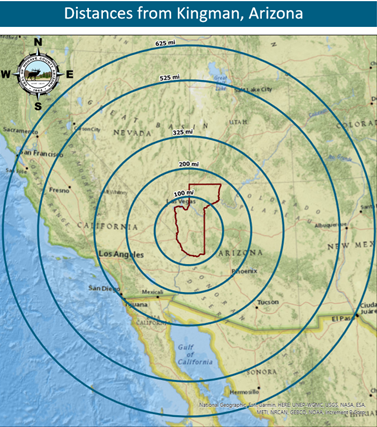
- Phoenix, AZ 195 miles
- Riverside, CA 285 miles
- Tucson, AZ 305 miles
- Los Angeles, CA 320 miles
- San Diego, CA 380 miles
- Albuquerque, NM 470 miles
- Salt Lake City, UT 525 miles
- San Jose, CA 575 miles
- San Francisco, CA 620 miles
- Denver, CO 855 miles
Rail & Highway Access
Mohave County’s strategic location and profitable proximity to West Coast markets offers a road to success.
Proximity to major West Coast markets and integrated transportation infrastructure makes Mohave County an attractive manufacturing, logistics, and distribution destination and allows companies to bring in raw materials and ship out finished products easily and efficiently.
Mohave County is strategically centered between Albuquerque, Las Vegas, Los Angeles, Phoenix, and Salt Lake City providing next-day freight delivery access to over 350 million people and climbing. Major east-west route Interstate-40 connects with Arizona SR-93 in Kingman, part of the NAFTA highway corridor linking the United States to Mexico and Canada (CANAMEX Corridor). In addition, the County is served by Class I rail service, with Kingman located on the main line of BNSF’s rail route.
Interstate 40
Interstate 40 (I-40) is an east–west Interstate Highway that has a 359.6-mile (578.72 km) section in the U.S. state of Arizona connecting sections in California to New Mexico. It enters Arizona from the west at a crossing of the Colorado River southwest of Kingman. It travels eastward across the northern portion of the state connecting the cities of Kingman, Ash Fork, Williams, Flagstaff, Winslow, and Holbrook. I-40 continues into New Mexico, heading to Albuquerque. The highway has major junctions with U.S. Route 93 (US 93) in Kingman, the main highway connecting Phoenix and Las Vegas, Nevada, and I-17 in Flagstaff, the Interstate linking Phoenix and Flagstaff.
For the majority of its routing through Arizona, I-40 follows the historic alignment of U.S. Route 66. The lone exception is a stretch between Kingman and Ash Fork where US 66 took a more northerly, less direct route that is now State Route 66. Construction of I-40 was ongoing in the 1960s and 1970s and reached completion in 1984.
US 93
US 93 begins at US 60 in Wickenburg, a small town about 50 miles (80 km) northwest of Phoenix. 30 miles (48 km) northwest of Wickenburg, it passes through a large forest of Joshua Trees, and is thus labeled the Arizona Joshua Parkway until it merges with I-40 to Kingman. US 93 then splits from I-40 in Kingman and heads north to the Hoover Dam. Chloride is located off this highway, and Santa's Land building remains are on the west side about 15 miles (24 km) before the Chloride exit.
US 93 enters Nevada on the Hoover Dam Bypass, then heads north through Boulder City towards Las Vegas. The route merges with U.S. Route 95 through Henderson and southeast Las Vegas, then continues north concurrently with Interstate 15 through North Las Vegas. Outside of the Las Vegas area, US 93 diverges from I-15 to head north towards Great Basin National Park. Near here, the highway overlaps with U.S. Route 6 and U.S. Route 50 towards Ely. US 93 leaves US 6/50 in Ely and continues north, intersecting Interstate 80 at Wells before crossing the Idaho state line near Jackpot.
Arizona State Route 68
State Route 68, also known as SR 68, is an east–west highway in northwestern Arizona running from its western terminus at its junction with State Route 95 in Bullhead City to a grade-separated interchange at U.S. Route 93 northwest of Kingman. The western terminus formerly extended just to the west of its current point to Davis Dam; this is now numbered as Mohave County Road 68.
State Route 66
"Get your kicks on Route 66"... State Route 66 is a relic of the former U.S. Route 66 (US 66), and is the only part of old US 66 in Arizona to have state route markers. Its western terminus is near Kingman at exit 52 on Interstate 40 and its eastern terminus lies near Seligman at exit 123 on Interstate 40.
Air
The impacts seen at general aviation airports are in direct relation to regional growth. As the number of business owners and individuals that travel by private aircraft increases, the more operations will be seen at destination, general aviation airports. The northwest Arizona region is supported by three municipal airports and one international airport. Each airport is unique and offers specific services to their communities.
Airports:
Colorado City Municipal Airport